


Major Winter Storm Blankets the US January 23
Major Winter Storm Blankets the US January 23
Meta description: A massive US winter storm January 2026 is unleashing heavy snow, treacherous ice, and brutal cold across 35 states from January 23-25. National Weather Service alerts warn of power outages, travel chaos, and life-threatening conditions—here’s what to know and how to stay safe.
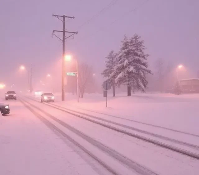
As of midday January 23, 2026, a powerful and expansive winter storm—referred to by some meteorologists as Winter Storm Fern—is rapidly intensifying and spreading across large portions of the United States. The National Weather Service (NWS) Weather Prediction Center has issued an extraordinary array of alerts: winter storm warnings, ice storm warnings, blizzard warnings, extreme cold warnings, and wind chill advisories covering parts of 35 states. More than 200 million Americans—roughly two-thirds of the population—are under some form of winter weather or cold-related advisory, with approximately 160 million facing active precipitation threats.
The storm is a classic “nor’easter-meets-Arctic-blast” hybrid: a deep low-pressure system pulling moisture from the Gulf of Mexico and Pacific while channeling bitterly cold Arctic air southward through a displaced polar vortex. This combination is producing a dangerous mix of hazards rarely seen on such a broad scale.
Storm Timeline and Path: Southern Plains to East Coast
The system’s evolution is following a well-forecast track, though slight northward shifts in recent model runs have increased snow potential in the Mid-Atlantic while intensifying ice risks farther south.
- Friday, January 23 (ongoing): Precipitation has already begun across the southern Rockies, High Plains, and parts of the Southwest. Heavy snow is falling in northeastern New Mexico, the Texas Panhandle, and western Oklahoma. A dangerous freezing rain/sleet mix is developing in central and eastern Texas, northern Louisiana, southern Arkansas, and Oklahoma. Accumulations of ice are beginning to glaze roads and power lines in these areas.
- Saturday, January 24: The storm center tracks northeastward through the Lower Mississippi Valley into the Tennessee Valley and Southeast. Crippling ice accumulations (0.5–1.0 inch or locally more) are expected across much of Texas, Arkansas, Louisiana, Mississippi, Alabama, Georgia, and the Carolinas. Heavy snow and sleet push into the Ohio Valley, central Appalachians, and parts of the mid-Atlantic. Blizzard conditions possible in portions of the northern Plains and Upper Midwest.
- Sunday, January 25–Monday, January 26: The system reaches the Northeast and New England. Significant snowfall (6–12+ inches, with localized 15+ inch totals) is likely from Pennsylvania through upstate New York, Vermont, New Hampshire, and Maine. Behind the storm, Arctic air surges in, locking in subzero temperatures and dangerous wind chills for several days.
Major Impacts Expected
This storm’s footprint and multi-hazard nature make it exceptionally disruptive:
- Heavy snow & sleet — Widespread 6–12 inch accumulations from the central Plains through the Northeast; isolated higher totals in favored orographic areas (e.g., Appalachians, northern New England).
- Damaging ice — Significant freezing rain in the southern tier (Texas to the Carolinas) threatens widespread power outages, tree damage, and structural strain. Ice accretion of 0.25–0.75 inch is widespread, with pockets exceeding 1 inch.
- Life-threatening cold — Wind chills dropping to -20°F to -50°F in the northern and central Plains, Upper Midwest, and eventually the Northeast. Even southern states will see lows in the teens to 20s with wind chills near or below zero—conditions that can cause frostbite in minutes.
- Travel paralysis — Major interstates (I-10, I-20, I-35, I-40, I-70, I-80, I-95) face hazardous to impossible conditions. Airports in Dallas-Fort Worth, Atlanta, Nashville, Charlotte, Washington D.C., Philadelphia, New York, and Boston are bracing for hundreds of cancellations and massive delays.
- Power grid stress — Ice-laden lines and tree damage could cause multi-day outages affecting millions, especially in the South and Southeast where infrastructure is less hardened against ice.
Safety Advice and Preparations
With impacts expected to last several days, preparation is essential:
- Assemble or refresh a 72-hour (ideally 7-day) emergency kit: non-perishable food, water (1 gallon per person per day), medications, flashlights, batteries, blankets, first-aid supplies, and a battery-powered or hand-crank radio.
- Protect pipes: Insulate exposed pipes, keep thermostat at least 55°F (even if away), let faucets drip slowly.
- If using space heaters or generators: Place generators at least 20 feet from the house, never indoors or in garages. Use carbon monoxide detectors.
- Driving: Avoid travel if possible. If you must drive, carry a winter kit (blankets, food/water, shovel, traction material, flashlight, charged phone). Keep full tank of gas.
- Cold safety: Dress in layers, cover exposed skin, limit outdoor time. Know hypothermia signs (shivering stops, confusion, slurred speech) and frostbite signs (numbness, pale skin).
- Check on neighbors, especially elderly or those with medical conditions.
Pro tip from years covering storms: In ice-heavy regions, photograph the condition of your roof and gutters now (if safe) for insurance claims later—many damage disputes arise from pre-storm vs. post-storm comparisons.
Comparison to Past Storms and Expert Insights
This storm’s scope draws comparisons to:
- The February 2021 Texas winter storm (Uri) — similar southern ice and power outage risk, but this system affects far more states.
- The 2014 polar vortex events — comparable cold depth and duration.
- The January 1994 “Storm of the Century” — broad snowfall and coastal impacts, though modern forecasting has improved lead time.
NWS senior meteorologist Tony Fracasso (Weather Prediction Center) stated: “This is shaping up to be one of the most widespread and impactful winter weather events we’ve seen in at least the last five to seven years.”
AccuWeather Chief Meteorologist Jonathan Porter added: “The combination of significant ice in the South, heavy snow farther north, and then an unrelenting Arctic air mass makes this a particularly dangerous and long-duration event.”
What to Expect: Snapshot View
- Friday–Saturday: Southern ice crisis begins; travel and power issues emerge.
- Saturday night–Sunday: Peak snowfall in Mid-Atlantic/Northeast; cold deepens everywhere.
- Monday onward: Dangerous cold persists; slow recovery from ice and snow accumulations.
Monitor weather.gov (enter your ZIP code for localized alerts), local NWS offices, and apps like NOAA Weather Radar.
FAQs
What is the US winter storm January 2026? A major multi-hazard winter storm affecting 35+ states January 23–26 with heavy snow, damaging ice, and life-threatening cold.
What does the winter storm forecast 2026 show for heavy snow and ice this weekend? Heavy snow (6–12+ inches) across the Plains, Midwest, Mid-Atlantic, and Northeast; significant ice (0.25–1+ inch) from Texas to the Carolinas.
Where can I find a winter weather alerts map 2026? Visit weather.gov or the NWS Weather Prediction Center website for real-time interactive alert maps.
How dangerous are the brutal cold alerts starting January 23? Extremely dangerous—wind chills to -50°F in northern areas and below zero even in the South can cause frostbite and hypothermia rapidly. Stay indoors as much as possible.
This storm is a reminder of winter’s power—stay vigilant, stay prepared, and stay safe.
By Rishwak Seasoned Environmental and Breaking News Journalist with over 15 years covering extreme weather, climate impacts, and natural disasters for international outlets and wire services.
Follow us for more
- Global news updates
https://worldreport.press/category/global/ - Bengaluru ranked second most congested city worldwide in 2025
https://worldreport.press/global/bengaluru-ranked-second-most-congested-city-worldwide-in-2025-tomtom-traffic/ - Mental health crisis global overview key insights January
https://worldreport.press/global/mental-health-crisis-global-overview-key-insights-january/ - New cancer vaccine update 2026 scientists report promising results January 22 2026
https://worldreport.press/global/new-cancer-vaccine-update-2026-scientists-report-promising-results-january-22-2026/ - How to create an AWS free tier account complete
https://worldreport.press/global/how-to-create-an-aws-free-tier-account-complete/

